
GPS Coordinates in Photos: Practical Uses of Location Data for Photographers (with IMatch examples)
GPS coordinates in photos are a form of metadata that records where an image was captured. Many digital cameras—and most smartphones—can embed this location data automatically (often called geotagging). In a digital asset management (DAM) system like IMatch, GPS and location metadata becomes a practical tool for organizing, searching, and enriching large photo collections.
Where GPS Coordinates Are Stored in Photo Metadata (EXIF GPS, IPTC, XMP)
In most workflows, GPS coordinates in photos are stored as metadata in the image file (or its sidecar): typically as EXIF GPS tags and/or as IPTC location fields stored in XMP. The coordinates themselves are just latitude/longitude (sometimes plus altitude, direction, and an accuracy estimate). They can come from a camera with built-in GPS, a smartphone, a separate GPS logger/track file, or manual placement on a map during culling.
Privacy note: location metadata is often exported and shared with the image. If you publish photos online (client galleries, social media, stock), decide whether you want to keep, strip, or generalize GPS data as part of your export preset.
Tip: The IMatch Batch Processor can export photos in many formats and gives you detailed control over the metadata to include.
Why Geotagging Matters in Real Photo Workflows
Even if you don’t care about maps, location data can be useful in day-to-day photography work:
- Search and filtering: find images by city, venue, trail, or shooting area—especially helpful when filenames and folders don’t encode location.
- Storytelling and captions: turn raw coordinates into place names (reverse geocoding) to speed up captioning and keywords.
- Project and client work: keep track of where a shoot happened (properties, events, travel jobs), and deliver consistent location metadata when required.
- Consistency across cameras: match images from multiple bodies by adding GPS from a track log or from reference shots made with a phone.
- Automation in DAM: use location as structured metadata to drive categories, smart collections, and batch tagging.
Working with Maps in a DAM (IMatch Map Panel Example)
IMatch includes a built-in Map Panel that displays images at the locations where they were taken. This gives you a visual overview of your travels and shoots, and it also lets you add, correct, or refine GPS coordinates directly in your database.
Example: photos taken during a city trip to London:
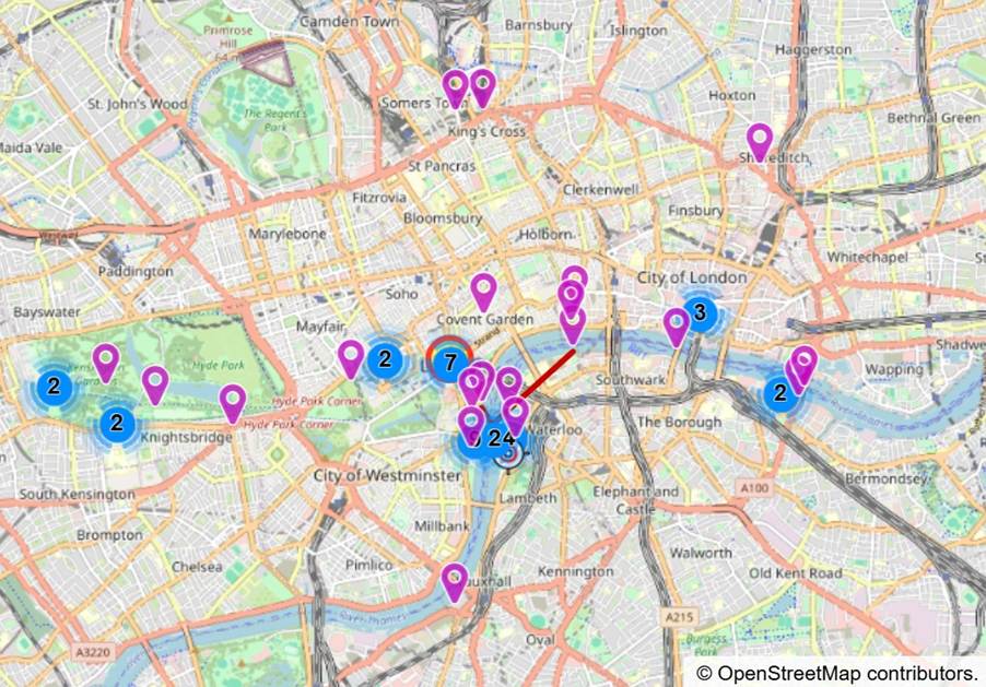
In this example, the Map Panel uses OpenStreetMap. The pink flags mark individual images. Blue circles appear when two or more images were taken very close to each other; as you zoom in, these clusters expand to reveal the individual flags.
Location Details
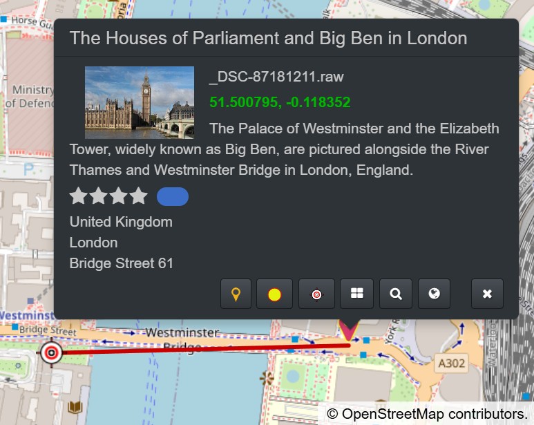
Results of reverse geocoding performed in IMatch displayed in the details popup available for each flag in the Map Panel.
Adding and Modifying GPS Coordinates in IMatch
To change an image’s GPS coordinates, drag its flag to a different position in the Map Panel. If you need maximum precision, enter latitude and longitude manually.
To add GPS coordinates to images that don’t have them yet, drag the files from a File Window onto the desired position in the Map Panel.
Accuracy, Pitfalls, and Best Practices
GPS data is not always perfect. Knowing the common failure modes helps you avoid wrong pins and misleading place names:
- Accuracy varies: phones can be very good outdoors but unreliable indoors or in dense cities; cameras with GPS may lag after power-on.
- Time synchronization matters: if you apply a GPS track log, the camera time must match the logger time (including time zone and daylight saving). IMatch offers features to match out-of-sync track log and image timestamps.
- Don’t over-trust reverse geocoding: services sometimes return different place names; review results for critical work.
- Generalize when needed: for sensitive subjects (home address, private locations), consider removing or reducing precision before publishing.
Finding Photos Using GPS Coordinates
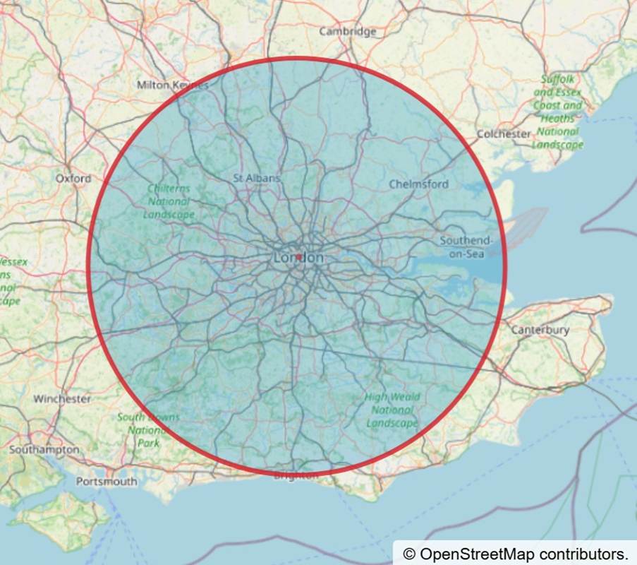
Once your files contain GPS coordinates, you can find photos taken in a specific area (for example, a city, park, or landmark) by selecting that area on the map. In the example below, we used a circle selection over London and surroundings to retrieve all photos shot within that region.
Finding Locations
Most mapping tools in DAM software provide place search: you type a location name (city, address, landmark) and the software jumps the map to that area. IMatch provides place search via GeoNames.org, Google Maps, and HERE. This gives you both a free option (GeoNames.org) and commercial options (Google Maps and HERE), so you can choose the service that best matches your requirements and budget.
Reverse Geocoding (Convert GPS Coordinates to Place Names)
Reverse geocoding is the process of converting GPS coordinates into human-readable location information (for example, country, city, street, or place name). In practice, it’s often used to speed up captioning, keywords, and structured location fields after you’ve added or corrected GPS coordinates. IMatch supports multiple services for reverse geocoding: GeoNames.org, Google Maps, and HERE.
GeoNames.org is a free service maintained by volunteers. Google Maps and HERE are commercial services that may offer better performance and, depending on the region, more detailed results. IMatch lets you pick the service that best fits your workflow and budget.
After running reverse geocoding, you can review (and edit) the results in the Metadata Panel in IMatch. For example:
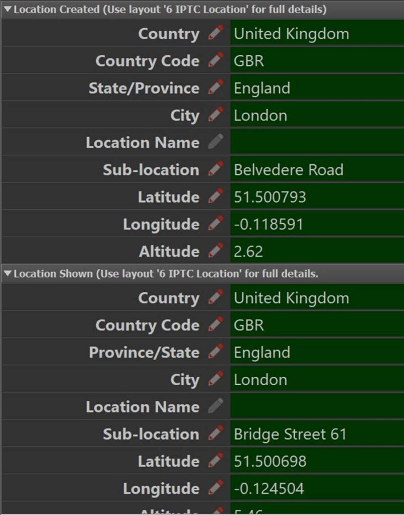
The image used in this example contains two sets of coordinates: Location Created and Location Shown. We used reverse geocoding to fill in the corresponding place names and hierarchical location fields for both.

Location Created and Location Shown
EXIF and IPTC metadata (stored in XMP) can distinguish between Location Created and Location Shown. Location Created describes where the camera/phone was when the photo was taken. Location Shown describes what the camera/phone was pointing at (the subject location).
In the image above, the red flag on the right marks the camera/phone position. The target marker on the left marks the location shown.
Note: For many use cases, Location Created is sufficient. For some types of photography, however, it can be important to know that the subject was 200 meters away from the camera position—or to record the camera direction at the time of capture.
Automatically Organizing Files By Their Location
IMatch can automatically organize images (and other files) by country, city, and location using data-driven categories. Below is a screenshot of categories IMatch generated from images taken in London, UK:
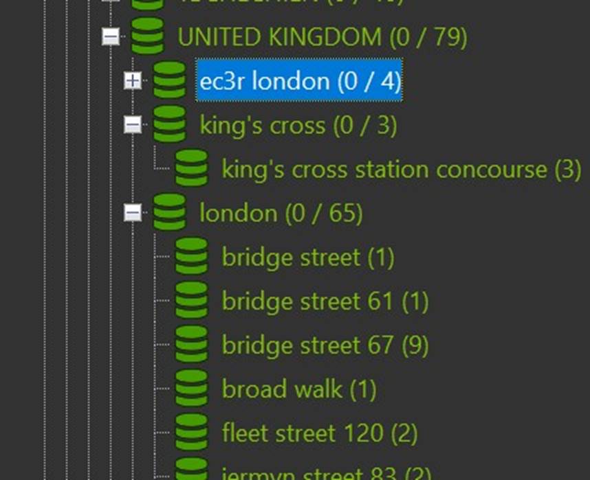
This makes it easy to find images from a specific place. Combine location categories with a time-based filter to answer questions like “Which images did I take in London in 2026?” in seconds.
IMatch Locations
To streamline processing (and to reduce lookups if you use commercial reverse geocoding services), you can use the Locations feature in IMatch.
An IMatch Location is a saved point on the map with an associated radius. You can store additional information such as country, city, ZIP/postal code, keywords, and a custom location name.
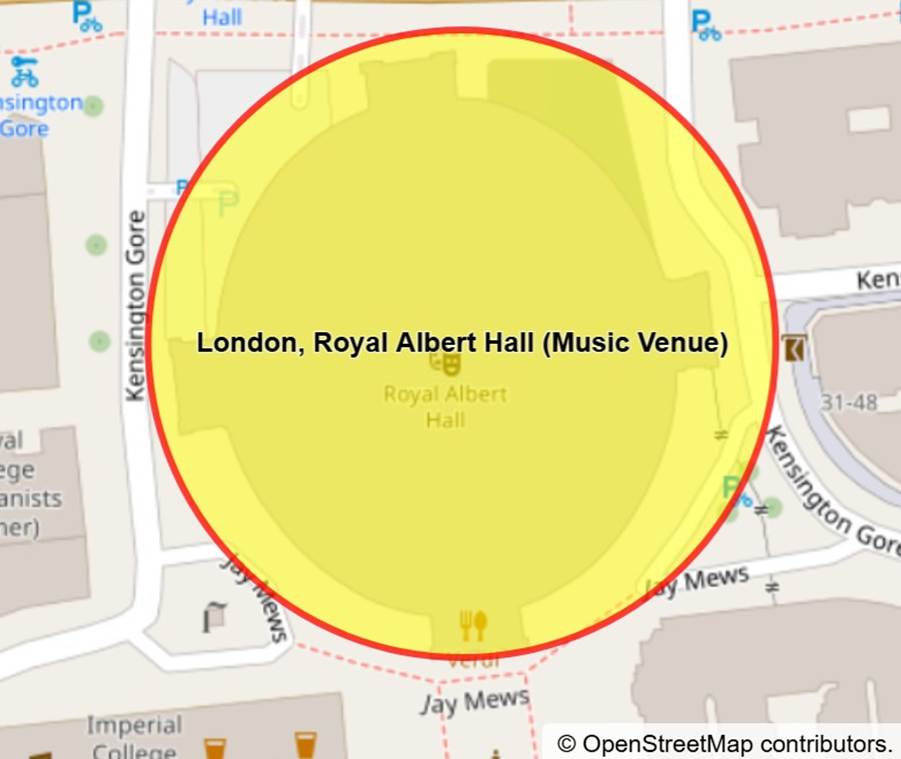
Locations have several purposes in IMatch:
- Quickly jump to saved locations in the Map Panel
- Find images taken at a location (taking the radius into account)
- Assign GPS coordinates, location data, and keywords using locations to any number of images
Summary
GPS coordinates and location metadata can do much more than put pins on a map. With GPS coordinates in photos, a DAM workflow can support faster search, more consistent organization, and better captions—whether you add missing coordinates, correct inaccurate GPS data, or convert coordinates into place names via reverse geocoding. Tools like IMatch build on these fundamentals with map-based editing, location-driven categories, and location presets.

Mario M. Westphal is the developer of IMatch, the digital asset management system (DAM) for Windows. He has a strong background in software development and photography, gained through working for over 30 years in the field for many clients. His special interests are photography, music. literature and of course software development, with a strong focus on digital asset management, database systems and image metadata. He hails from Germany.
You can reach him in the IMatch user community and via support@photools.com.